Map of Forţeni
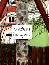
Forțeni locality, located only 5 km from Odorheiu Secuiesc, probably originated at the beginning of the 12th century. Crossed by three streams, the town has two parts: Susani and Josani. The Reformed church was built by Catholics around 1450. It was damaged by the earthquakes of 1756 and 1798, and suffered in the major flood of 2005. Notes from 1641 attest to the existence of a school in the locality. The priest Lőrincz Áron has a real cult here, in the locality where he served for 47 years, being also a teacher during the second war.

Forțeni , Photo: Csedő Attila

Forțeni , Photo: Csedő Attila

Forțeni , Photo: Csedő Attila
Forțeni , Photo: Csedő Attila

Forțeni , Photo: Csedő Attila

Forțeni , Photo: Csedő Attila

Forțeni , Photo: Csedő Attila

Forțeni , Photo: Csedő Attila

Forțeni , Photo: Csedő Attila

Forțeni , Photo: Csedő Attila

Forțeni , Photo: Csedő Attila

Forțeni , Photo: Csedő Attila

Forțeni , Photo: Csedő Attila
Source: welcometoromania.ro
GPS: 46.30650N, 25.23609E
Map type


