Map of Zetea
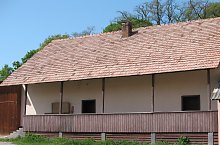
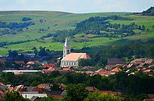
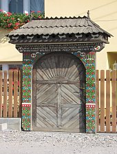
The first document attesting the village dates from 1332. Formerly Zetea village hearth was on the hill Csere, but after being burned by Tatars reached the current site. It is a Catholic village, between years 1590 and 1612 was the diaconal office. In the sixteenth century it was among the most populated places in Transylvania. He had several churches, the current was built in the twentieth century. Just 10 km from the village was built the largest dam in the area. Szekler gates crowd attracts visitors

Zetea , Photo: Miklós Tünde

Zetea , Photo: Csedő Attila

Zetea , Photo: Csedő Attila
Zetea , Photo: Péter Andrea

Zetea , Photo: Csedő Attila

Zetea , Photo: Csedő Attila

Zetea , Photo: Csedő Attila

Zetea , Photo: Csedő Attila

Zetea , Photo: Csedő Attila

Zetea , Photo: Csedő Attila

Zetea , Photo: Csedő Attila

Zetea , Photo: Csedő Attila

Zetea , Photo: Csedő Attila
Zetea , Photo: Csedő Attila

Zetea , Photo: Csedő Attila

Zetea , Photo: Csedő Attila
Source: welcometoromania.ro
GPS: 46.39071N, 25.36732E
Map type