Map of Lake Leşu: Lesu Lake
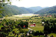
Situated at a distance of 20 km far from the road E60 the collecting lake Lesu was put into use in 1973. It has a surface of 148 hectares and a water volume that can be kept behind the barrage of 28,3 million cubic meter.
The lake's water aliments the Lesu hidro-electric power plant that was put into use 4 years after in 1977. The Tail of the Lake became better and better populated so it transformed into a real vacation village where the ground-plot gets ever expensive from year to year. The drive that goes by the lake gets to the Stana de Vale tourist hostel. So the Lesu lake became a gate to the Bihor-Vladesa mountains.

Lesu Lake , Photo: WR

Lesu Lake , Photo: WR

Lesu Lake , Photo: WR

Lesu Lake , Photo: Sorin Stanciu

Lesu Lake , Photo: Hám Péter

Lesu Lake , Photo: Sorin Arina

Lesu Lake , Photo: WR

Lesu Lake , Photo: WR

Lesu Lake , Photo: WR

Lesu Lake , Photo: WR

Lesu Lake , Photo: WR

Lesu Lake , Photo: WR
Lesu Lake , Photo: WR

Lesu Lake , Photo: WR

Lesu Lake , Photo: WR

Lesu Lake , Photo: WR
Source: welcometoromania.ro
GPS: 46.80491N, 22.57447E
Map type


