Hartă Lacul Leşu: Lacul Lesu
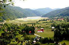
Situat la 20 de km de la drumul E60, Lacul de acumulare Leșu a fost dat în folosință în anul 1973. Are o suprafață de 148 hectare și un volumul de apă ce se poate reține în spatele barajului este de 28,3 milioane mc.
Apa lacului alimentează hidrocentrala Leșu, care s-a dat în folosiță cu patru ani mai târziu, în anul 1977. Coada Lacului, a devenit din ce în ce mai populată, asfel s-a format un adevărat sat de vacanță, unde prețurile terenurilor cresc de la an la an.Drumul forestier care trece pe lângă lac ajunge până la Cabana Stâna de Vale. Astfel Lacul Leșu a devenit o poartă către Munții Bihor-Vlădeasa

Lacul Lesu , Foto: WR

Lacul Lesu , Foto: WR

Lacul Lesu , Foto: WR

Lacul Lesu , Foto: Sorin Stanciu

Lacul Lesu , Foto: Hám Péter

Lacul Lesu , Foto: Sorin Arina

Lacul Lesu , Foto: WR

Lacul Lesu , Foto: WR

Lacul Lesu , Foto: WR

Lacul Lesu , Foto: WR

Lacul Lesu , Foto: WR

Lacul Lesu , Foto: WR
Lacul Lesu , Foto: WR

Lacul Lesu , Foto: WR

Lacul Lesu , Foto: WR

Lacul Lesu , Foto: WR
Sursa: welcometoromania.ro
GPS: 46.80491N, 22.57447E
Tip hartă


