Aranyosmeggyes (térkép)
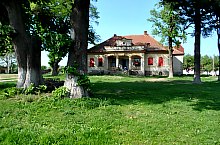
Aranyosmeggyes ősrégi település, a régészek kő, bronz és népvándorlás kori leletekre bukkantak. Első írásos emléke 1271-ből származik. Vára a XIII. században épült. 1409-ben mezőváros, de a vár lerombolása után hanyatlik. A XIX. század birtokos listáin a Teleki, Wesselényi és Károlyi családok is megjelennek a XX. században pedig a Boros, Böszörményi, Wesselényi és Teleki családok is. A település Aranyos elnevezését a hajdani várkastély aranyozott mennyezetű ebédlőjéről kapta, míg a meggyes elnevezést a területén lévő meggyes ültetvényről.
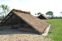
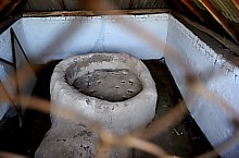
Aranyosmeggyes, Látnivalók

Aranyosmeggyes , Fotó: WR

Aranyosmeggyes , Fotó: WR
Aranyosmeggyes , Fotó: WR

Aranyosmeggyes , Fotó: WR

Aranyosmeggyes , Fotó: WR

Aranyosmeggyes , Fotó: WR
Aranyosmeggyes , Fotó: WR

Aranyosmeggyes , Fotó: WR

Aranyosmeggyes , Fotó: WR

Aranyosmeggyes , Fotó: WR

Aranyosmeggyes , Fotó: WR
Aranyosmeggyes , Fotó: WR

Aranyosmeggyes , Fotó: WR

Aranyosmeggyes , Fotó: WR

Aranyosmeggyes , Fotó: WR
Forrás: welcometoromania.ro
GPS: 47.78778N, 23.13085E
Térkép típus


