Map of Medieşu Aurit
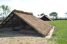
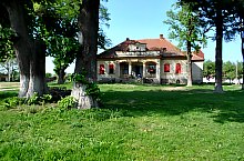
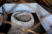
Medieșu Gilt is an ancient city, archaeologists found artifacts from the Stone Age, Bronze Age, and the time migrations. The locality is documented since 1271. The fortress was built in the 13th century after its demolition and the locality declines. The 19th century was the family of Teleki, Wesselényi and Károlyi, and of the twentieth century, Boros, Böszörményi, Wesselényi and Teleki. Interesting is also the origin of the name of the locality. Gilded gilded ceiling refers to the living city and expression Medieșu Hungarian cherry plantation.
Medieșu Aurit, Sights

Medieșu Aurit , Photo: WR

Medieșu Aurit , Photo: WR
Medieșu Aurit , Photo: WR

Medieșu Aurit , Photo: WR

Medieșu Aurit , Photo: WR

Medieșu Aurit , Photo: WR
Medieșu Aurit , Photo: WR

Medieșu Aurit , Photo: WR

Medieșu Aurit , Photo: WR

Medieșu Aurit , Photo: WR

Medieșu Aurit , Photo: WR
Medieșu Aurit , Photo: WR

Medieșu Aurit , Photo: WR

Medieșu Aurit , Photo: WR

Medieșu Aurit , Photo: WR
Source: welcometoromania.ro
GPS: 47.78778N, 23.13085E
Map type


